Basics
Home and Search
Site Guide
Brentford Basics
Privacy Policy
Contact
People
Families
Photos of people
Name indexes incl WW1
Memories
Lists, Documents, News
Occupations
Properties
Properties: High Street
Properties: non-High Street
Photos
Maps
1909/10 Valuation Index
Pub Hub
Can You Help?
Seeking...
Mystery photos
Roads Off
A-Z list
Janet's Research
History
Beach's Jam
Nowell Parr
Turner the Artist
Queen Victoria 1840
Brentford Market
80 High Street
Clitherow of Boston House
Four Croxford Brothers
Sources & More
They Said
Books etc.
Web Links
Next
Site Technology
Author
Home and Search
Not Brentford
|
|
Home -> Maps Intro -> You are here -> Section to the West | Section to the East
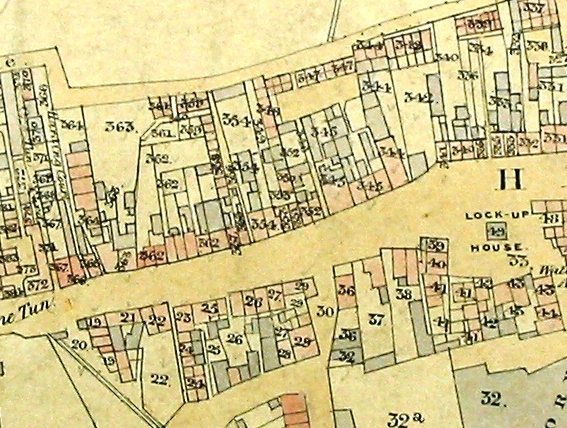
Tithe Map of Ealing showing the One Tun and to the east, Old Brentford, 1839/41
This image is reproduced courtesy of Corporation of London, London Metropolitan Archives
The property numbers on the map are those used in the tithe apportionment and are not the same as the house numbers allocated in 1876. Dwellings are shaded pink, work places, churches, outbuildings etc. are shaded grey
In the notes below tithe refs. are prefixed 'T', High Street house numbers have no prefix.
 |
|
On the northern side of the High Street, working eastwards:
- (T372/254): the One Tun is marked with Old Spring Gardens to its west, One Tun Yard to its east
- 'Harding Court' is marked, running between (T366/257) and (T365/257-1)
- (T362/258-264): a parcel of land owned by John Grimault, the description indicates 7 houses and gardens occupied the plot but there look to be 8 on the map
- (T354/266): The Cannon, to the west Cannon Alley is visible; John Grimault owned the plot T354
- (T345/273-276): four houses and premises owned by John Grimault; the western most property was the Kings Arms, with Kings Arms Alley to the west
- (T344/277): James Fletcher owned 4 houses and premises on this plot and presumably occupied the large house fronting the High Street, rather than the three smaller ones on Back Lane
- (T342/278 and 279): numbers 278 and 279 were later built here
- (T366/283): the pathway to the east leads to Eatons Court
- (T331/288 and 289): later Rattenburys; to the east lies the access to the Albany Chapel
On the southern side of the High Street, working eastwards:
- (T22/70): Pump Alley lies to the east
- (T29/61): Town Meadow lies to the east
- (T36/60): a house, stable and yard, Brentford's police station
- The Cage Square includes The Cage (T49), 'Lock-Up House'
- (T32): the Soap Factory behind Cage Square, owned by Thomas & L Rowe, who also owned (T29 and T36)
- (T48): 7 almshouses, Ferry Lane
Details of owners and occupiers.
Published 2005; updated March 2010
|
|
|
