Basics
Home and SearchSite Guide
Brentford Basics
Privacy Policy
Contact
People
FamiliesPhotos of people
Name indexes incl WW1
Memories
Lists, Documents, News
Occupations
Properties
Properties: High StreetProperties: non-High Street
Photos
Maps
1909/10 Valuation Index
Pub Hub
Can You Help?
Seeking...Mystery photos
Roads Off
A-Z listJanet's Research
HistoryBeach's Jam
Nowell Parr
Turner the Artist
Queen Victoria 1840
Brentford Market
80 High Street
Clitherow of Boston House
Four Croxford Brothers
Sources & More
They SaidBooks etc.
Web Links
Next
Site Technology
Author
Home and Search
Not Brentford
Brentford Redevelopment, update from Ballymore, February 2022
The south side of New Brentford is being redeveloped by Ballymore, the following excerpt is from their February newsletter (thanks to Janet McNamara for forwarding.
In March 2023 Janet sent a photo of the site plan which has been added after the two images from Ballymore.
What has happened on site in January and February?
There has been a flurry of construction activity at the Brentford Project as work progresses on a number of blocks here in our new waterside mixed-use district.
Installation of the 66-home Block K's precast columns is well advanced, and parapet and coping are going into place on the roof of Block K West. Scaffold strike and cladding and balcony installation are due to be completed by early August. Internally, first fix drylining and mechanical and electrical installation and second fix drylining and ceiling closure are all in progress.
At the same time, blockwork is installed to the perimenter of the 107-home Block B West and windows are going into place, while the setting out of party walls is also in progress.
Block C West and East, comprising 144 homes, is continuing, with the reinforced concrete frame now topped out, and construction is starting in earnest on the 18-home Block A3 as piling works are imminent.
Notes
The view below looks down across the site, orientation is close to the plan beneath - north is straight ahead. As to older landmarks, the Town Hall is pretty central, a small white block and the High Street runs across the view in front of it. To the right of the Town Hall are St Paul's church spire and the former police station and section block - the white tower block. At the right edge the splash of colour is the car park.
In the foreground the Brent loops with Augustus Close crossing it. Left centre, the tower of St Lawrence's Church is paler than the body of the church, amongst the trees.
As to the new developments, the Block K West and East are nearest, behind them are the Block B West and East and to the right Block C West and East. No sign of Block D as yet.
 |
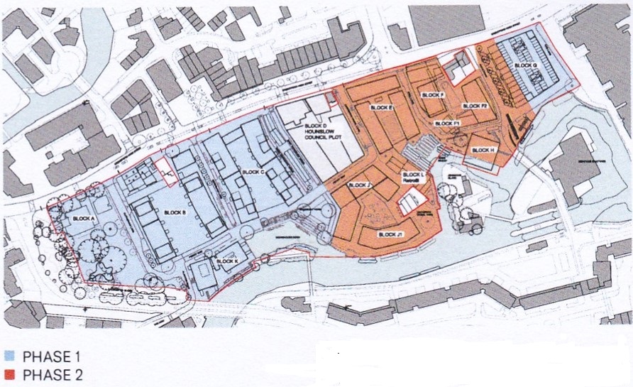
The plan shows the two development phases.
 |
Janet's photo from March 2023: 'plan of the south of the High Street on hoardings in the area behind St Lawrence's Church'. It includes the names of the blocks and other features: Ctrl+ to enlarge.
 |
Links
Photos by Janet McNamara charting the new development.
January 2021 has a view of the car park, the colourful splash to the right of the first image, also a satellite view of the site and earlier version of the above plan.
Published March 2022; updated April 2023