Basics
Home and SearchSite Guide
Brentford Basics
Privacy Policy
Contact
People
FamiliesPhotos of people
Name indexes incl WW1
Memories
Lists, Documents, News
Occupations
Properties
Properties: High StreetProperties: non-High Street
Photos
Maps
1909/10 Valuation Index
Pub Hub
Can You Help?
Seeking...Mystery photos
Roads Off
A-Z listJanet's Research
HistoryBeach's Jam
Nowell Parr
Turner the Artist
Queen Victoria 1840
Brentford Market
80 High Street
Clitherow of Boston House
Four Croxford Brothers
Sources & More
They SaidBooks etc.
Web Links
Next
Site Technology
Author
Home and Search
Not Brentford
Union Court
Union Court ran south off the High Street, between numbers 24 and 25, and down to the river Thames.
A few notes follow from research, starting with coming across Union Court in the 1810 Land Tax record and continuing to the 1890s. No explanation has been found for its name.
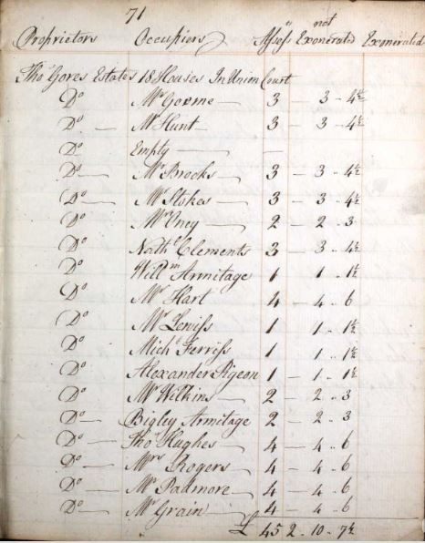
In the 1810 Land Tax, Thomas Gore's Estates included 18 houses in Union Court.
 |
This record is from the Ancestry website, their London Land Tax collection. Old Brentford was in Ealing parish at the time and in the 1810 book Old Brentford records started at page 33. Union Court was recorded towards the end of Old Brentford on page 71. Transcription (abbreviations expanded) of tenant names and assessments Mr Goome £3 |
When Abraham Beck prepared his will in 1827 he referred to 'my copy-hold property in Union Court situate in Old Brentford at present in the possession of my brother John BECK & which at his decease comes to me to be sold as soon as conveniently can after my executors or administrators come into possession of it either by public auction or private sale'. (See more about Beck's will)
The area referred to is shown in the 1839/1841 tithe map of Ealing, I reckon plot 81, an empty area, any houses having been cleared as the next item shows.
Morning Herald (London) 12 September 1842
NOTICE is hereby given that, on the 18th day of October next application will be made to her Majesty's Justices of the Peace, assembled at Quarter Sessions, in and for the county of Middlesex, at the Sessions House, Clerkenwell Green, in the said county, for an order for STOPPING UP a certain HIGHWAY, court or passage, over and along a piece of ground on which stood several messuages called UNION COURT, and leading out of the street of OLD BRENTFORD, in the parish of Ealing, in the county of Middlesex, through, over, and along certain land and premises there, of which one John Hazard is the owner, of the length of 173 feet or thereabouts, and of an undefined width, and in lieu thereof to make and appropriate for the use of the public an open or uncovered right of way at the western extremity of the said land and premises of the said John Hazard, leading from the said street of Old Brentford aforesaid, to or towards the river Thames, of the length of 157 feet, and of the breadth of five feet; and that the certificate of the two justices, having viewed the same, with the plan of the old and proposed new highway, will be lodged with the Clerk of the Peace for the said county, on the said 18th day of October next.
BENJAMIN GELDING, Surveyor of the Parish of Ealing, Middlesex,
August 26, 1842.
The 1:1056 Ordnance Survey map published in 1895 shows the right of way running down to the Thames between the Royal Brewery and Royal Hotel. Map measurement tools (available on the Royal Library of Scotland website) confirm it is 157 feet in length. The track can be spotted on the 1894 OS map next to the Half Moon and Seven Stars, 25 High Street.
Published November 2021