Basics
Home and SearchSite Guide
Brentford Basics
Privacy Policy
Contact
People
FamiliesPhotos of people
Name indexes incl WW1
Memories
Lists, Documents, News
Occupations
Properties
Properties: High StreetProperties: non-High Street
Photos
Maps
1909/10 Valuation Index
Pub Hub
Can You Help?
Seeking...Mystery photos
Roads Off
A-Z listJanet's Research
HistoryBeach's Jam
Nowell Parr
Turner the Artist
Queen Victoria 1840
Brentford Market
80 High Street
Clitherow of Boston House
Four Croxford Brothers
Sources & More
They SaidBooks etc.
Web Links
Next
Site Technology
Author
Home and Search
Not Brentford
Poppets Parlour
The delightfully-named Poppets Parlour was on the south side of the High Street at its eastern end, just to the west of the Salutation Almshouses. The 1836 Poor Rate notes John Bond owned small houses called Poppets 'Place'. This is the earliest reference found to Poppet's Parlour so far. The latest reference is a birth certificate dated 1871.
Other courts, buildings and alleys are named after owners, inns or beerhouses, but no evidence has been found for a local Poppet. Parlour is an unusual description too, suggesting a small, snug space.
The following notes use censuses, the tithe records of 1840 and later Ordnance Survey maps to establish more about Poppets Parlour and its residents.
The 1841 census and tithe took place almost exactly a year apart and both name people who lived there: a good starting point.
1841 census
In 1841 the census enumerator worked his way westwards along High Street, noting the Salutation Almshouses with their eight almswomen, followed by
- High Street
- John Baker, 70, bargeman and family
- Mary E Burford, 70, independent who lived on her own
- Poppets Parlour: five households
- Edward Tappin, 50, labourer and wife
- Robert Morris, 40, labourer and James and Sarah Gibbs
- Edward Kelley, 60, carpenter and wife
- Mary Wood, 50, laundress, daughter and Dinah Pearce
- William Knowles, 25, gardener and family
- An unihabited property
- High Street
- Richard Kelley, 30, carpenter, wife and family (7 in total); also John Wells, 30, cap maker and his wife
- Anne Gomme, 45, pottle basket maker and family (5 in total)
- Joseph Stuckey, 60, bargeman, wife and Henry Gardener, 30, wife and young son
14 people were recorded at Poppet's Parlour in 1841, all born in Middlesex except Edward Kelley and his wife Harriet. Another 19 people lived in the three properties recorded after Poppet's Parlour. All but two of the 19 (John Wells and wife) were born in Middlesex.
Two properties were recorded between the almshouses and Poppet's Parlour in 1841, later numbers 7 and 8 High Street.
1840 Tithe
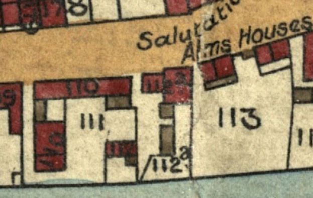
The tithe records are dated 13 June 1840, just under a year before the census. The tithe map section below shows the almshouses and area immediately to the west:
 |
Working west from the almshouses on plot 113, plot 112a is next to but not adjoining them and is two semi-detached houses, with different frontage lines. The eastern property has a yard running down to the Thames, its neighbour a yard with two outbuildings and a passage on its western side, no river frontage.
Next west is a square-ish area, plots 110 and 111. Plot 110 is two terraced blocks, one on the High Street and a second at right angles to it, making two sides of the courtyard, plot 111. An outhouse links the two blocks. There is an entry to the west of 110 leading down to the river then east to the court. The court contains another building, plot 112, with a small yard and Thames frontage.
The tithe records owners and occupiers plus a brief description of the properties. The records for plots 112a, 112 and 110:
- 112a:two houses and yards, owner M E Burford, occupiers M E Burford and John Baker
- 112: house, owner John Bond, occupier John Snelling
- 110: eight houses and yard, owner John Bond
The occupiers who lived here in 1841 are annotated with their census address, PP - Poppets Parlour; HS - High Street:- William Knowles PP
- Edward Kelley PP
- William Nokes
- Edward Morris (PP)
- Elizabeth Tent
- Joseph Stuckey HS
- Edward Tappin PP
- Mary Wood PP
- Richard Kelley HS
- 111: court, owned by John Bond
The order of occupiers may be as recalled by the owner and not reflect exactly where they lived in the two blocks on plot 110.
Taking the census and tithe together
Combining information from the census and tithe, Mary Burford and John Baker lived between Poppet's Parlour and the almshouses in the semi-detached properties 112a. John Baker, bargeman, may have occupied the house with river frontage, his neighbour and landlord, Mary E Burford, the adjoining property.
Next, John Bond owned nine properties in the tithe, 110 (8) and 112 (1). John Snelling occupied 112 in 1840 but was not recorded here in 1841; 112 could be the uninhabited property noted after Poppets Parlour in the census.
Of the nine tenants who occupied eight properties in 110 in the tithe, six were also recorded in the census at a mixture of Poppet's Parlour and High Street addresses; a seventh, Edward Morris (tithe), may be related to Robert Morris (census); finally, William Nokes and Elizabeth Tent from the tithe are not recorded here in 1841. One new occupant was noted in the census: Anne Gomme.
There is a third contemporary record: John Bond, owner of Poppet's Parlour, made his will four days after the tithe:
'I give and devise all my copyhold or customary estate called Poppets parlor consisting of nine messuages or tenements with the land and hereditaments situate at Old Brentford aforesaid held of the Lord of the Manor of Ealing subject to a quit rent of one shilling and two pence a year unto my dear wife Ann'.
John Bond's will was proved 15 years later.
It is concluded Poppets Parlour had eight properties in two blocks (110) and a ninth, detached property (112). In the census one block was recorded with a High Street address. Whilst the block running along the High Street seems most likely to be counted as part of it, there are instances where properties running off the High Street were numbered as part of it too, for example numbers 2, 171 and 195 High Street (1:2500 OS maps from 1959/1960 survey). Where the front doors were may have influenced the order in which people were recorded in the census and their address.
1851 census
Ten years on, the enumerator again worked westwards, recording the almshouses, then an unoccupied house and a house occupied by Joseph Baker, 23, engraver (master); 'Poppets Parlor' followed:
- John Casey, 52, labourer (garden), wife Mary S 42, garden woman, seven children ages 2 months to 18 years and Mary Lynch, relation, widow, 83 (all born in Ireland)
- William Heywood, 33, Thames waterman, born Brentford; wife Elizabeth and three children, all born Brentford
- David Wrought, 25, sawyer born Windsor, Berkshire, wife Susan 23 born Kew, Surrey and two children born in Brentford
- Susan Langston, widow, 50, charwoman born Brentford
- Timothy Cronin, 48, labourer (garden), wife Hannah 48 garden woman, and five children ages 16 to 30
In the same house Michael Mechan or Meehan?, 28 and wife Hannah 23, all nine occupants were garden labourers or garden woman, born in Ireland - John Snelling, 34, Thames waterman, wife Mary and baby John 10 months, all born Brentford
- Charlotte Weatherley, widow, 60, greengrocer and two adult children
- Ann Gomme, widow, 56, pottle-basket maker and a relation
- William Pearce, 25, fisherman (Thames), wife and daughter
In 1851 32 people lived in six houses addressed as Poppet's Parlour (one block) and eight in the three properties recorded after at High Street addresses (the other block). Two of the families were from Ireland and worked in market gardens; whether they stayed permanently or came for just the growing season has not been established.
Only two families were here in both 1841 and 1851: John Snelling and Ann Gomme. Snelling was recorded as the last householder in Poppet's Parlour in 1851, which fits his being in the detached property (plot 112 in the tithe). Ann Gomme was recorded in the middle of three High Street properties in both censuses.
A note regarding John Snelling: the record of his binding to John Snelling senior as a Thames Waterman is dated 10 August 1837, he was free 13 April 1848 (Findmypast). A marriage on 31 August 1849 of John Snelling, waterman, son of John Snelling, waterman, to Mary Mills at St Mary's Ealing, bride and groom of Old Brentford, fits.
An outbreak of cholera hit residents in 1853: 'Filthy Irish court' implies the residents were responsible for the filth; there was prejudice against Irish people at the time. In 1861 the enumerator worked eastwards. Seven properties were recorded in 'Popets Parlour' occupied by 26 people, none born in Ireland. The almshouses were recorded two properties after Poppet's Parlour. The household heads follow and include the five properties recorded on High Street immediately before P.P.; some may have been part of Poppet's Parlour. Numbers in brackets are the total in each household.1861
Ann Gumm matches in age and occupation the Anne Gomm(e) from 1841 and 1851 and was consistently recorded at a High Street address, next but one to Poppet's Parlour. In 1861 there was a small enclave of basket makers here.
John Snelling is the only other individual found here in earlier censuses; in 1861 he was in the third property recorded with a Poppet's Parlour address. He was a lighterman, wife Mary Ann and four children.
 |
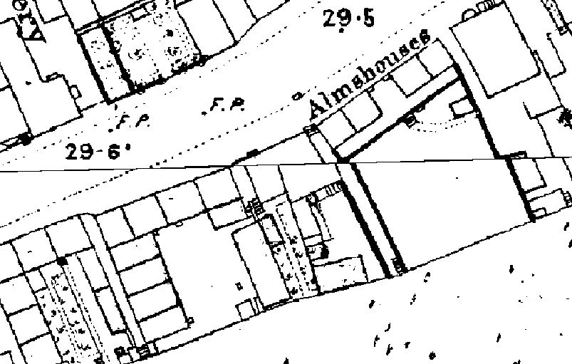
The Ordnance Survey map prepared around 1867 shows each of the two blocks making up Poppet's Parlour divided into four. As no shading was used to differentiate between homes and outbuildings or, for that matter, empty space, it is not certain there were eight homes in total. The paths to the river Thames are more clearly defined than in the tithe map and those to the west of P.P. had steps at the river end.
1871
Lynn Hayter has researched the Hutchinson and Haywood families. Her family tree includes the birth of James Henry Hutchinson, 5 March 1871, at Poppet's Parlour: the latest reference found to P.P. so far.
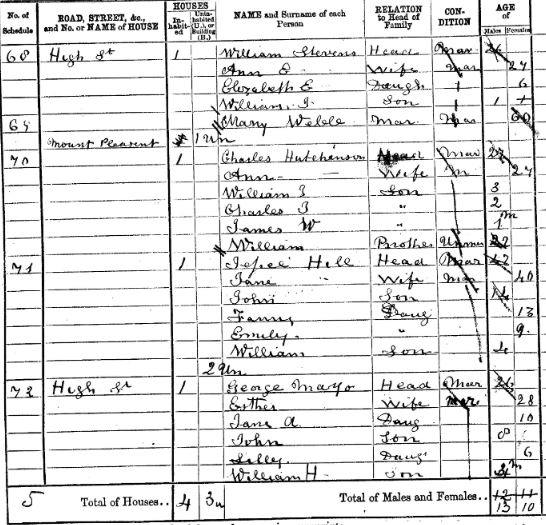
It seems unlikely the Hutchinsons would move house with a small baby before the census was taken, 2 April 1871. The family was found on page 16 and the almshouses on page 18 of the same Old Brentford enumeration district, so they were living in the right area. No Poppet's Parlour address is noted in the census; the properties before the Hutchinsons and up to the almshouses were all recorded as High Street or Mount Pleasant.

The excerpt shows Charles Hutchinson and family.
The enumerator worked eastwards, but below are the household heads in reverse order, as the almshouses and two houses after it are a constant. The list starts with the property after no. 8 and finishes further west along the High Street; this should cover the area where Poppet's Parlour was.
- John Phelp, 26 coal porter (1); also Thomas Blumin 35, woodcutter (7); also John East, 28, hawker (4)
- George Mayo, 26, labourer at Water Works with two lodgers (9); also Edward Newman, 29, unemployed (4); also Henry Harrison, 63, baker unemployed (5)
- Mount Pleasant
- two uninhabited properties
- Jesse Hill, 42, carter (6)
- Charles Hutchinson, 27, carman (6)
- one uninhabited property
- High Street
- William Stevens, 26, carpenter & joiner (5)
- William Gye, 44, beer seller (9)
- Charles Martin, 41, labourer (5); also William Webb, 30, waterman (3)
The first two properties noted above included three or more family units, a total of 30 people; none of the surnames have been noted before.
William Gye, the beerseller, is thought to have been at 12 High Street, from previous research. This helps sandwich Charles Hutchinson between the almshouses at number 6 and beerhouse at number 12: this is the site of Poppet's Parlour.
In which case, why was the address 'Mount Pleasant' noted for the Hutchinson family, which is at odds with the birth certificate address? Lynn thought this might be the name of a property and she could be right.
The enumerator did not ditto addresses but noted changes of street name. The excerpt above may show five properties at Mount Pleasant in 1871, or an unoccupied property with this address followed by four others, two unoccupied.
One piece of evidence that links another property here to Poppet's Parlour is the presence of Jesse Hill in 1871, as he lived in Poppet's Parlour in 1861.
I conclude Jesse Hill and his neighbours, the Hutchinson family, were at Poppet's Parlour in 1871.
If you have family from Mount Pleasant, Brentford then they may have lived in one of the terrace of 12 properties of this name off the north side of the High Street, Old Brentford. The records of Mount Pleasant occupiers in 1861 and 1871 have been noted and it is clearly a different location.
After 1871
In the 1881 census, as in 1871 there is no reference to Poppets Parlour, although the properties may have been recorded as part of the High Street. A search of the area should clarify.
The gas works expanded into this area in stages and by the time the 25 inch to the mile OS map was prepared in the 1890s, the block off the High Street had gone. The block on the High Street is shown as four properties with yards or gardens down to the Thames. There is a narrow entry or passage between the second and third properties. To the west, the passage with steps down to the Thames remains, as does that west of the Almshouses.
 |
As at May 2023, there are no references to Poppet's Parlour, Brentford in the British Newspaper Archive. There are pieces about a sale in 1804 of a field of this name in Yardley, east Birmingham. It is possible Brentford's Poppet's Parlour was once a field of this name. Half Acre may have the same origins.
Have you come across any references to Poppet's Parlour in your research? Please get in touch if you can add to this page.
Links
Notes on the Bond and Boxall familes of Old Brentford, includes a link to a transcription of John Bond's will.
The History of Brentford website has more information about the cholera epidemic of 1853.
The 1936 Poor Rate includes the earliest reference to 'Poppets Place'; transcription by Vic Rosewarne.
Lynn Hayter has researched the Hutchinson and Haywood families, some of whom lived in Poppets Parlour.
The history of the section of the High Street near Poppet's Parlour will be revised in light of the above.
Published June 2023