Basics
Home and SearchSite Guide
Brentford Basics
Privacy Policy
Contact
People
FamiliesPhotos of people
Name indexes incl WW1
Memories
Lists, Documents, News
Occupations
Properties
Properties: High StreetProperties: non-High Street
Photos
Maps
1909/10 Valuation Index
Pub Hub
Can You Help?
Seeking...Mystery photos
Roads Off
A-Z listJanet's Research
HistoryBeach's Jam
Nowell Parr
Turner the Artist
Queen Victoria 1840
Brentford Market
80 High Street
Clitherow of Boston House
Four Croxford Brothers
Sources & More
They SaidBooks etc.
Web Links
Next
Site Technology
Author
Home and Search
Not Brentford
Boston (Manor) Road, Brentford
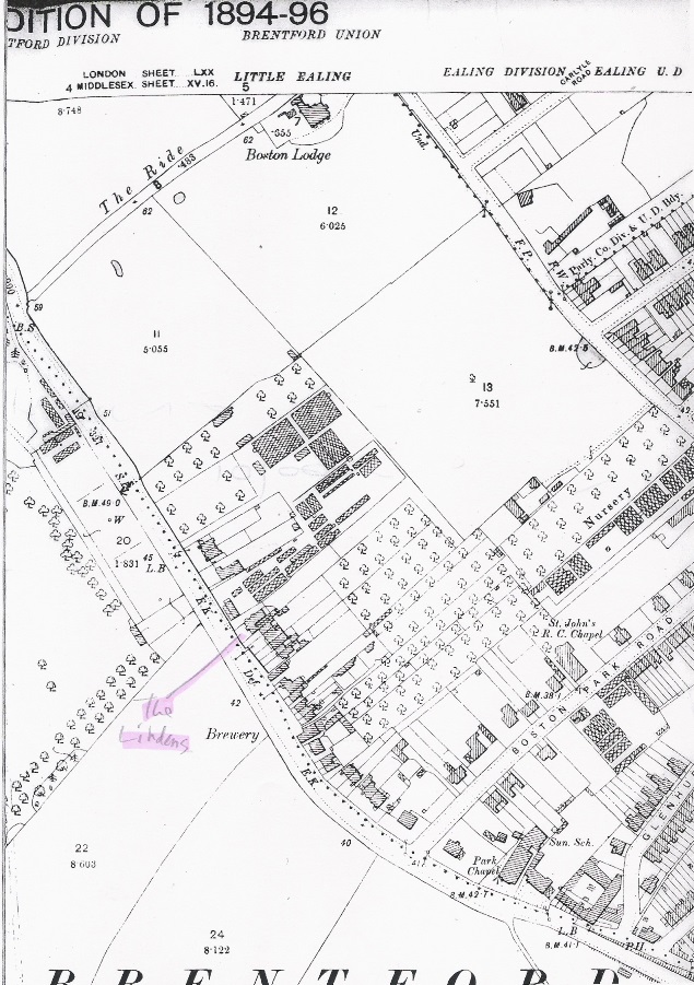
 Boston Road runs from Half Acre to the north west out of Brentford and formed the parish boundary between Hanwell (later New Brentford) and Ealing (later Old Brentford), shown as a dotted line on the 1894-6 OS map.
Although marked as 'Boston Road', by 1935 it was known as 'Boston Manor Road' and previously (OS map published 1869) was 'Boston Lane'. Lindens is marked at no. 73 (thanks to Janet McNamara, Carolyn Hammond and Vin Miles) - see links below for a postcard view of this house.
The 1894-6 OS map includes a wealth of detail, marking letter boxes, chapels, a Sunday School and larger houses such as Boston House by name. Nearer town, the map shows development on both sides of the road as far as Inverness Lodge, but after that the west side of the road remained fields. The map shows a Public House at the town end: this was the King's Arms at no. 19. The Brewery marked further north was between numbers 53 and 55, originally the Star Brewery but named the Boston Brewery by the time the 1894 street directory was compiled.
Thanks to contributors the site has material about several properties and also some postcards. Starting from the southern end near the town and working northwards into the open countryside:
- Brentford Congregational Church, Boston Road, around 1910; the building is now used by the Brentford Free Church
- New Grove Mansions, 7 Boston Manor Road
- Inverness Lodge, 9 Boston Manor Road
- Postcard view of Clifden House, the former council offices from around 1907-1911
- Brentford Hospital, around 28 Boston Road, 1975 (opposite Brentford Central Station)
- 19th century drawing of the Park Baptist Chapel
- Postcard from around 1909 showing Lindens, 73 Boston Road
- Postcard showing the entrance to The Ride, early 1900s
- Painting by Augustine Ballin, ca 1900
- Boston Farm, early 1900s postcard
- The Clitherow family of Boston House which gave its name to the road
Other photos of Boston Road appear in:
- Archive Photograph Series Brentford: Boston Manor Road entrance to Beldam's Packing and Rubber Company, 1960s (A91), which was built at the southern end of field 13 in the map; Brentford Past has a brief history of Beldam Tyres (Q115) (Julie Jakeway has provided a photo of the workforce around 1912)
- Archive Photograph Series Brentford: the above postcard image (A92)
- Archive Photograph Series Brentford: similar view to the postcard but taken in the 1930s, by which time houses lined both sides (A92)
- Archive Photograph Series Brentford:entrance gates to Boston Manor House 1918 (A94)
- Brentford As It Was: view taken around 1900 looking south towards Park Baptist Chapel (C37)
- Brentford As It Was: winter scene with the gates to Boston Manor House, around 1900 (C38)
- Brentford & Chiswick As It Was: winter scene pre 1905, same view as postcard (D16)
- Then & Now Brentford: view north from near the junction with Boston Park Road, around 1905 (S45)
- Then & Now Brentford: modern view from similar point to the above (S45)
See 'Books etc.' for details of local history books referenced above.
Published April 2016; last updated January 2023