Basics
Home and SearchSite Guide
Brentford Basics
Privacy Policy
Contact
People
FamiliesPhotos of people
Name indexes incl WW1
Memories
Lists, Documents, News
Occupations
Properties
Properties: High StreetProperties: non-High Street
Photos
Maps
1909/10 Valuation Index
Pub Hub
Can You Help?
Seeking...Mystery photos
Roads Off
A-Z listJanet's Research
HistoryBeach's Jam
Nowell Parr
Turner the Artist
Queen Victoria 1840
Brentford Market
80 High Street
Clitherow of Boston House
Four Croxford Brothers
Sources & More
They SaidBooks etc.
Web Links
Next
Site Technology
Author
Home and Search
Not Brentford
Spring Gardens
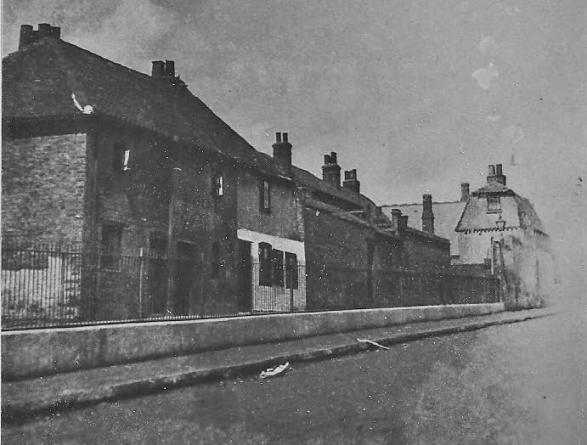
Arthur Peters sent this photo and also did some fine detective work to explain the history of this unusual road, with elevated properties on one side. Patsy Langley added further local knowledge in August 2013.
The view is looking north, the High Street was behind the photographer.
 |
(Old) Spring Gardens was a narrow alley between numbers 253 and 254 High Street; it was a little higher than the High Street road level and was accessed from the High Street by a flight of three steps. No. 254 was the One Tun public house.
 Between the One Tun and no. 255, running parallel to Spring Gardens, was One Tun Yard. The One Tun was demolished (around 1905) along with the outbuildings behind it causing Spring Gardens and One Tun Yard to merge.
However Spring Gardens retained its elevation above the High Street road level, as is clear in this photo. Spring Gardens runs off to the left near the lamppost. Alexandra Road, the new thoroughfare at High Street level, continues north to meet Back Lane.
'Just past the white painted house were some doors which led into the Sunday school hall which I think may have been a very old school at some time.' (In 1834 non-conformists opened a British School in Old Spring Gardens (Q103), I think this became the Sunday School, Arthur mentions.)
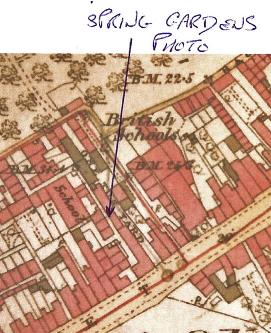
1894 OS map showing Old Spring Gardens and the One Tun. Google Street View shows the County Court building on the western corner of Alexandra Road and High Street is elevated with railings along the Alexandra Road side - an echo of the past.
Patsy Langley added, August 2013: I remember these old buildings being in existence just before Alexandra Road and the County Court were built, around the mid-Sixties. The school shown on the Arthur Peters map is St. Pauls, part of which was destroyed by fire in the past fortnight. The whole area was demolished in the mid-1960s, Spring Gardens having been replaced by a block of flats bearing its name in Albany Road.
Kings Arms Alley is still there. A former doctor's surgery stands on the right of the photo nowadays. It has been acquired by Social Services. Nos. 233-248 High Street were demolished later than the Spring Gardens/One Tun Yard area, since I can remember Sergeants Funerals and an old bendy toy shop being in existence circa 1970. These buildings were derelict by then, though. My mum told me that the funeral business here, Sergeants, handled my grandmother's funeral in 1950. It was black-fronted, plate glass window with gravestones and grave cups on display.
The reason why Spring Gardens (and Alexandra Road) were/are elevated from the High Street is because the High Street at that point sweeps up the valley. It is quite a steep climb up Alexandra Road and hence the elevation (and former steps and railings of Spring Gardens.) I don't believe that One Tun Yard ever had railings, but I stand to be corrected on this.
Links
Photos of Alexandra House from 2019 and earlier include more information about this area.
Photos from 1966 of 240-246 High Street.
Published February 2011; last updated February 2024