Basics
Home and SearchSite Guide
Brentford Basics
Privacy Policy
Contact
People
FamiliesPhotos of people
Name indexes incl WW1
Memories
Lists, Documents, News
Occupations
Properties
Properties: High StreetProperties: non-High Street
Photos
Maps
1909/10 Valuation Index
Pub Hub
Can You Help?
Seeking...Mystery photos
Roads Off
A-Z listJanet's Research
HistoryBeach's Jam
Nowell Parr
Turner the Artist
Queen Victoria 1840
Brentford Market
80 High Street
Clitherow of Boston House
Four Croxford Brothers
Sources & More
They SaidBooks etc.
Web Links
Next
Site Technology
Author
Home and Search
Not Brentford
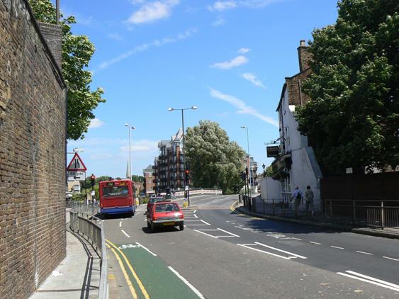
View towards Brentford Bridge
 | |
A view from London Road, Isleworth (also known as 'Brentford End') looking easterly towards Brentford Bridge. A sign for Commerce Road to the left is just visible above the bus; the spire of St Paul's church rises above it. The pub on the right is O'Briens freehouse, at 11 London Road, Isleworth. In the foreground the brickwork marks the site of a former railway bridge. This branch of the GWR gave access to Brentford Dock; it opened in 1859 and closed in 1964, providing a freight service during this period; it also carried passengers between 1860-1915 and 1920-1942 (Alan Godfrey OS map reprint, Brentford, 1894) Thanks to Dave Stoneleigh who provided this photograph, taken on June 28th 2008 during the Brentford Festival weekend. Return to smaller key page or return to larger key page. Alternatively use your 'back' button to return to a the last page you visited. |